Right before Israel’s second lockdown last week, I had the opportunity to take a trip up north for some peace and quiet before being confined to a one kilometre radius for the next three weeks.
Although it wasn’t the intended theme of the trip, while there I also got up to some ‘border spotting’ on the frontiers with Lebanon, Syria, and Jordan.

I’m never quite sure how widespread being interested is in borders is — if at all. In fact, the only evidence I have to suggest that some other humans are interested in the subject is the /r/borderporn subreddit which has more than 50,000 subscribers.
I believe that my interest in visiting borders dates back to visiting Nicosia, Cyprus as a child on vacation. Nicosia has an international border running right through it between the almost entirely unrecognized Turkish Republic of Northern Cyprus (TRNC) and southern Cyprus. The fences, fortifications and border markings are images that still stick with me. These days — not so far from Cyprus — I can see some border lines and crossings on my own terms.
Israel’s Four Land Borders

A yellow Hizbullah flag flies in southern Lebanon as seen from the Eastern side of Metullah adjacent to Nahal Ayun. Hizbullah regularly positions propaganda posters warning of an impending invasion in Hebrew and ensures that these can be clearly seen from the Israeli side. Such ongoing psychological warfare is a hallmark of the shadow conflict between Israel and the Lebanese militant group.
Israel has land borders with four countries: Lebanon, Syria, Jordan, and Egypt.
Of these, Israel is legally and technically at war with both Lebanon and Syria while there are peace treaties with both Egypt and Jordan. Although in Israel’s early days the (then open) Jordanian border was a restive one, with cross-border fedayeen attacks from that territory, these days the most volatile borders are those on the north with Lebanon and the de facto border between Israel and the Gaza Strip which was recently host to a protracted period of protests.
Although UN Security Council Resolution 1701 called for a disarmament of Southern Lebanon and the absence of troops other than the Lebanese Armed Forces (LAF) to the south of the Litani River, Israel’s recent discovery and neutralization of a series of cross-border Hizbullah attack tunnels demonstrates what even the street cats in Israel know: that Hizbullah is active in Southern Lebanon right under the noses of UNIFIL, the UN peacekeeping mission which is supposed to monitor the implementation of the various UN resolutions affecting the territory.
Northern Border: Lebanon / Blue Line
Israel’s northern border with Lebanon is — de facto — the same thing as the UN Blue Line which was originally drawn for the purpose of determining whether Israel had withdrawn its troops from southern Lebanon. Part of UNIFIL’s mandate involves marking these out with centimetric precision in coordination with both Israel and the Lebanese Armed Forces.
This job might seem simple but can result in armed standoffs between the two sides as captured in this fascinating YouTube video. This video provides more interesting information about how UNIFIL demarcates the Blue Line which it marks — literally — with blue cylinders.
Because Israel and Lebanon are at war there is no civilian crossing between the two territories. There is one crossing at Rosh HaNikra which leads to Naqoura on the other side, which is host to UNIFIL headquarters. This crossing is only used by UN personnel although on occasion Israel and Lebanon have exchanged POWs through it.
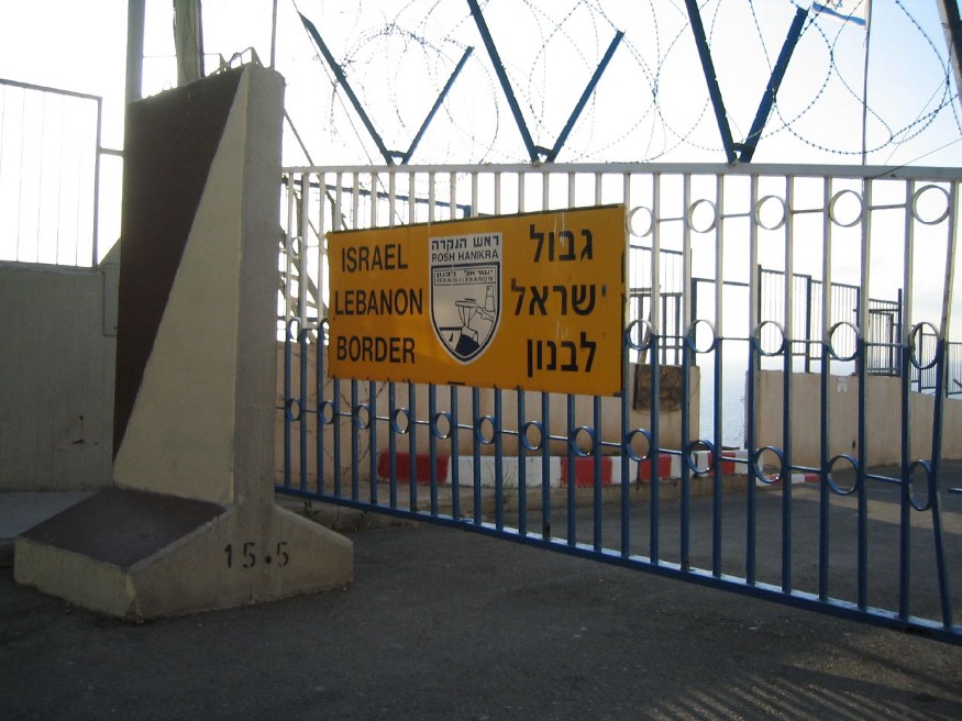
Civilians are not able to access the border by Rosh HaNikra and its fencing is not visible from the popular grotto tourist site below. A series of buoys are used to designate the border’s extension into both countries’ territorial waters.

Tracing the border in Google Maps from Rosh HaNikra eastwards, one can find various Israeli border towns and nature reserves which directly abut the border — including the controversial Sheba Farms which can be driven through by taking Route 999 westwards towards Ghajar.
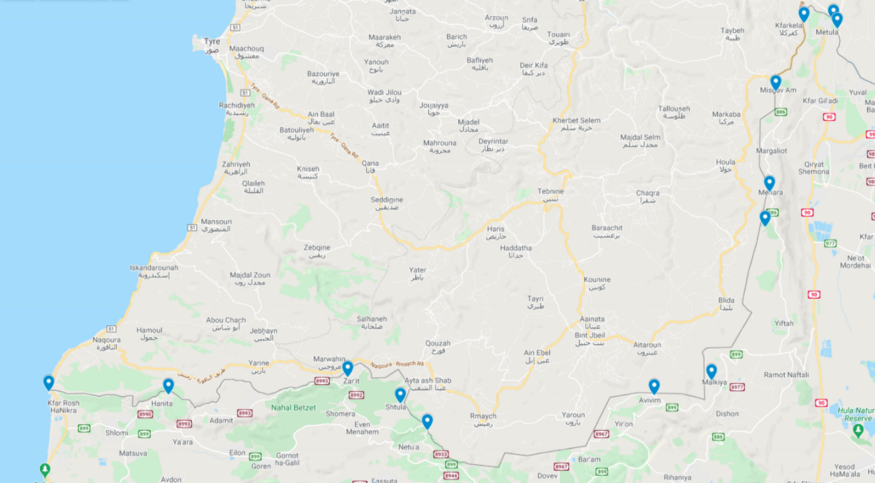
Among the most conspicuous of these is Ghajar which appears to run over the Blue Line.

Ghajar has its own fascinating history but unfortunately civilians are not generally allowed to enter without explicit permission from the army and an invitation from somebody in the town. The Jerusalem Post has an interesting write-up about the Alawaite village here.
Among the most impressive places to see the border is Metulla — which is Israel’s northermost town. Metulla is surrounded on three sides by
Among the most impressive and best-known places to see the border is Metulla — which is Israel’s northermost town.
Metulla is surrounded on three sides by Lebanon and the border and Blue Line wraps around the town — sometimes at a distance of a kilometer at other times at a distance of five meters.

Immediately to the West of the village is the Lebanese town of Kfarkela where one of the discovered Hizbullah attack tunnels was located submerging. The IDF is on record as stating that that town and Aadaysit Marjaayoun — which directly abuts Misgav Am and is located immediately south of Kfarkela— are meeting points for Hizbullah special forces.
Hizbullah has made explicit its plans to launch a ground invasion of Northern Israel from this part of Southern Lebanon and has even used environmental NGOs as fronts to conduct close-range reconnaissance on Northern Israel from this area.
Despite the fact that it is reasonable to assume that this part of the Lebanese border is under continual close observation from both sides, the nature surrounding Metulla — where the border wraps and mere hundreds of meters from the hilltops where Hizbullah flags flutter — is deceptively lush and peaceful (the territory around the border with the Gaza Strip is similarly pastoral).

The border fence runs right along the northern half of the town — it is literally on the side of the road. To the west, the fence runs along a Lebanese road running parallel to Kfarkela. To the east, the border — and the Blue Line markers — are within meters of the Nahal Ayun nature reserve with its breathtaking waterfall.

Around Metulla, Lebanon is so close that individual cars, houses, and people can be clearly seen with the naked eye — as well as the aforementioned Hizbullah flags and posters. It’s a strange place. Beautiful. But deceptively quiet.
Syria: DMZ / Purple Line
Israel doesn’t have a border with Syria — another enemy state — per se.
Rather, a DMZ exists between the two countries which is manned by UNDOF, another UN mission with another mandate of keeping the two countries — and their militaries — apart.
The border between Israel and its side of the DMZ — UNDOF Line Alpha — is what is commonly referred to in the media as the ‘Israel Syria border’.

Relative to the Lebanese border, media reports indicate that Israel’s border with the Syrian DMZ has been quieter — although Israeli territory and civilians have occasionally been caught in errant crossfire between rebels and pro-government forces battling just across the fence.
Relative to Lebanon, there are less Israeli towns and sites from which to see the Syrian DMZ (Alpha Line) border up close. Perhaps the best site is in the Druze village of Majdal Shams. The road which skirts the town’s eastern edge runs right next to the border fence. If you’re curious, search for directions to Givat Htisaacott and you’ll soon see Israel’s characteristic smart fence.
It’s worth explaining for a moment what a typical border in Israel actually looks like — because it differs a little from the image that the media creates.
Except in places where they are fortified with concrete walls and additional fortifications, Israel’s borders typically consist of a steel fence, a patrol road, sand to spot infiltration attempts, and another fence. Unless you know it’s there — and minus a few sensors jutting out of it — it doesn’t look vastly different from the perimeter fence of an airport or a line of wire a farmer might use to demarcate the boundaries of his land.
Typically, a sliver of land before the border itself is fenced off and the land behind it (between it and the actual border) is declared a closed military zone (CMZ; Hebrew: שטח צבאי סגור). Civilians can access up to the fence marking the start of the military zone — although many mistake that fence for the border itself. The military zone abutting the border varies in its width. In less security-conscious times, some of Israel’s borders were open — or only marked by a single “offline” fence or a coil of barbed wire. Although that has changed, it is reasonable to assume that most true surveillance remains unseen.
There is only one crossing between Israel and the DMZ with Syria at Quneitra. It is mostly used by clergy, UN personnel, and for special purposes by the Druze population of northern Israel — such as selling apples or sending brides to be married to Syrian Druze. The last of these uses was the subject of The Syrian Bride.
Jordan

Unlike the Syrian and Lebanese borders, Israel’s border with Jordan is technically one between two nations at peace.
Therefore, unlike the Lebanese and Syrian borders there are three crossings open to civilians: near Beit Shean, at Allenby Bridge, and at Aqaba — the Jordanian city directly opposite Eilat.
Israel’s border with Jordan follows three main sections.
- In the north, it follows the course of the Jordan River. With the exception of pilgrimage sites, the fence on the Israeli side is generally set some meters before (West of) the river — sometimes at a surprisingly wide berth.
- Then, the border follows through the center of the Dead Sea. The presence of the border — running through the center of the Dead Sea — is not typically noted or signed at some of the popular Dead Sea tourist beaches.
- Finally, it becomes a land border — stretching all the way from the southeastern tip of the Dead Sea through to Eilat where the border fence separates Eilat and Aqaba.
There are a few sites on the Israeli side where one can get right up to the border (on the river) and see into Jordan. The ones I recommend visiting are: Gesher Adam (Damia Bridge) — which served as a goods transit point between Israel and Jordan up until the Second Intifada — and Qasr El Yahud. The latter is a pilgrimage site by day and a closed military zone by night. Israel demarcates its border in the river with a series of buoys. A Jordanian religious site is located ten meters across the river flanked by a Jordanian flag. In Israel, it’s harder to get much closer to neighboring countries than this (without visiting them!)


Egypt
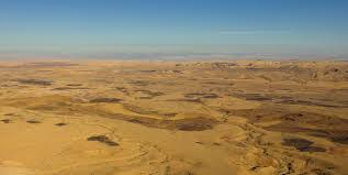
Israel’s long land border with Egypt meanders through the Negev Desert stretching all the way from Eilat to the Gaza Strip. This being arid desert country, there aren’t many Israeli communities or sights that abut the border so relative to the borders with Jordan, Lebanon, and Syria there’s less to see.
There is only one major crossing with Egypt. The Nitzana Border Crossing is used only for commercial trade between the two countries. The border for tourists to cross into Sinai, and then the rest of Egypt, is located at Taba which is an Egyptian seaport directly south of Eilat.

Crossing the border involves passing through an Israeli terminal and then walking through a long tunnel that involves entering a territory that feels like a No Man’s Land but which is technically in Egypt. After a short walk, one arrives at the Egyptian border control facility. An Egyptian sports center abuts the maritime part of the border as it stretches into the sea. I have no idea how access is controlled. Over land, the border is a commanding steel fence meandering between the mountains of the desert and can be seen from the hotel resorts of Taba itself.
Other Border Photos